Elaboration on this Achievement Objective
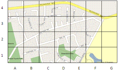
This means students will use co-ordinate systems that are used on maps to specify location and direction (for example Greensborough Reserve is at D1, Ruakura Road runs West-East). The scale of a map indicates distance.
At Level Three students should be able to:
- Give the location of something using co-ordinate references, for example A3.
- Find the location of something given a co-ordinate reference, for example Find Daphne Street at E8.
- Use features of a map to describe movement that would get someone from one location to another, including distance and direction. This includes turns (right, left relative to orientation), main compass directions (N,W,S,E) and approximate distances in metres or kilometres.
- Follow a set of directions given in terms of turns and distances (as above) and show that path they walked on a map of the area.