This is a level 4 activity from the Figure It Out series.
A PDF of the student activity is included.
Click on the image to enlarge it. Click again to close. Download PDF (1481 KB)
Geometry is the study of shape, size, relative position, and space, and is one of the oldest branches of mathematics. The literal meaning of geometry is to “measure the Earth”. The accuracy with which we measure depends on both our needs and the sophistication of the tools available. The use of GPS technology enables people to pinpoint places on Earth with incredible speed and accuracy. In these activities, students explore latitude and longitude.
access to the Internet
a globe or an atlas
FIO, Technology Transformations, Levels 3+-4+, Where on Earth?, pages 15 - 17
These activities will develop students’ understanding of latitude and longitude and how they are used to describe locations. Using technology appropriately and using spatial visualisation to solve problems develops the key competency using language, symbols, and texts.
Some students wrongly perceive mathematics to be unrelated to them or their culture. In reality, mathematics is found in all cultures. For example, Polynesian peoples skilfully navigated across thousands of kilometres of ocean using sophisticated navigation techniques. Navigation skills were highly valued and were passed down orally, often by song. Important facts were memorised: the motion of specific stars and where these stars would rise and set on the ocean, weather conditions, times of travel, wildlife species and cloud formations on particular islands, the direction of ocean swells, colours of sea and sky, angles for approaching harbours. Consider inviting a parent or community member with knowledge in these areas to talk to the class.
Discuss with the students why it is useful to be able to identify a location. What situations require greater accuracy than others? Provide opportunities for students who share a first language other than English to discuss their ideas in this language.
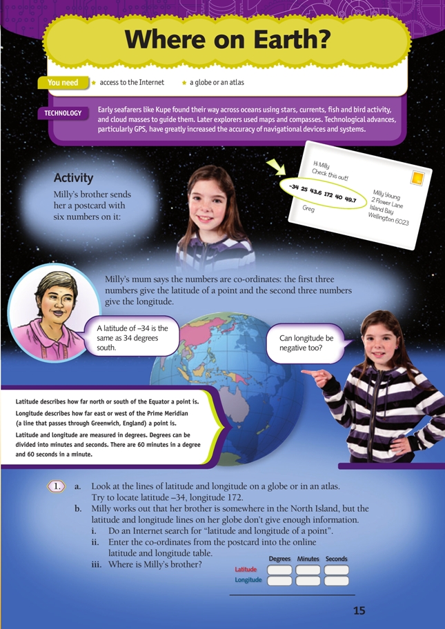
Latitude and longitude are used to describe the position of any point on the surface of the Earth. 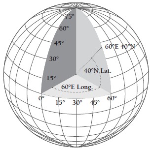
Latitude and longitude are angles. Imagine a giant 40° angle with its vertex the centre of the Earth. One arm of the angle lies along the horizontal plane of the Equator. The other arm travels through the Earth until it reaches a point on the surface of the planet. This point has a latitude of 40°N.
The “distance” between the arms of the angle will be small near the vertex (the centre of the Earth) and large at the ends (the surface of the Earth), but the angle between the two arms is constant. On the surface of the planet, the distance between two points that are 1 degree of latitude apart is approximately 111 km. There is slight variation because the Earth is not a perfect sphere.
A degree can be divided into 60 minutes and each minute can be further divided into 60 seconds.
The latitude at the Equator is 0°, at the North Pole, it is +90°, and at the South Pole, it is –90°. One way for students to remember that lines of latitude are horizontal is to imagine the horizontal rungs of a ladder (“ladder-tude”).
Longitude lines on a globe (also known as meridians) meet at the poles and are widest at the Equator (about 111 km apart).
0° longitude is called the Prime Meridian. This meridian runs through the site of the British Royal Greenwich Observatory in London. The degrees continue 180° east and 180° west until they meet and form the International Date Line in the Pacific Ocean.
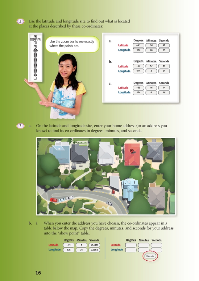
Explore the latitude and longitude website (http://itouchmap.com/latlong.html) yourself before doing this activity with your class. Familiarise yourself with how to enter the information and answer parts of question 3.
For question 1b (ii), the students need to enter the latitude and longitude values on the right-hand side of the screen where it says “Show point”. There are similar boxes on the left-hand side that should not be used.
For question 3, the students need to enter their address at the top of the webpage.
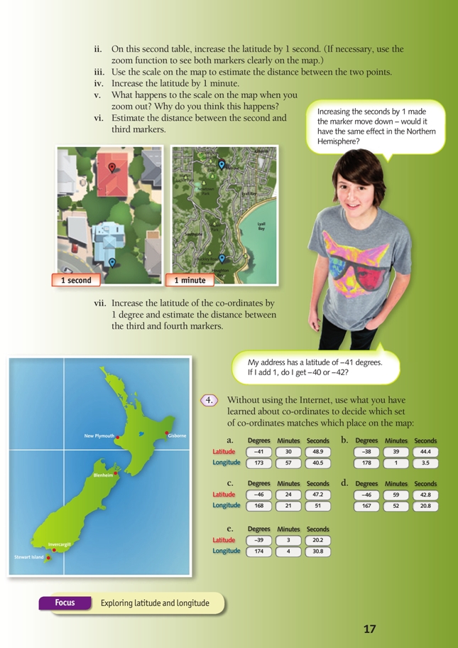
Students may need guidance using the scale on the map. One approach is to use an object, such as a finger width, part of their pencil’s length, or a ruler to define a set measurement from the scale. They can use this to see how many of this “unit” fit between the two points. Answers need only be estimates.
In question 4, students apply their knowledge of latitude and longitude to match co-ordinates with places on a map. Ask them to communicate how they determined which co-ordinates belong with which place and to listen to methods used by other students.
As a homework activity, the students could research systems of navigation, both historical and in current use. For example, how do people living in vast deserts locate objects they have buried? How did our Polynesian ancestors find and colonise Aotearoa? How did a sextant work?
Extension
A: Metres, nautical miles, and knots
The metre unit was originally defined as 1/10 000 000 (one ten-millionth) of the distance between a pole and the Equator.
If the distance from a pole to the Equator is 10 000 000 m and that corresponds to 90 degrees of latitude, what is the shortest distance between two points that differ by 1 degree of latitude?
Answer: 10 000 000 ÷ 90 = 111 111 m = about 111 km
The distance between two points with co-ordinates that differ by 1 minute of latitude can be found by dividing this distance by 60:
1 degree of latitude ÷ 60 = 1 minute of latitude
111 111 m ÷ 60 = 1 852 m (to the nearest metre)
This distance is known as a nautical mile and is used for measuring distances at sea. Boat speed is traditionally measured in knots. A knot is a speed of 1 nautical mile per hour, for example, a 50-knot wind moves at a speed of 50 nautical miles per hour.
B: Explore the impact of adding/subtracting whole numbers to/from negative numbers.
Start with the problem mentioned in the student book: “If I add 1 (to – 41), do I get – 40 or – 42?”
The students can use a vertical number line to show different latitudes and then use number lines to solve problems: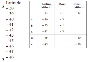
Answers
a. – 43
b. – 41
c. – 39
d. + 6
e. + 6
“+1” represents a movement of 1 degree north (up).
Ask the students how they could represent a movement of 1 degree south (down).
Examples of possible problems: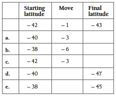
Answers
a. – 43
b. – 44
c. – 45
d. – 7
e. – 7
Have the students draw up their own table and fi ll in the “starting latitude” and “move” columns so that the final latitude is always – 43, checking each other’s answers using their number lines.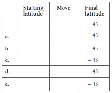
Encourage the students to generalise patterns that they notice while doing the calculations, for example, “If I add on to a negative number, it becomes less negative.”
Support for English Language Learners
Supporting students with subject-specific vocabulary
Begin by deciding what vocabulary is important only for understanding the text and what language students are likely to encounter in many contexts. Focus language learning on the latter. Guide students as to which words are most important for them to learn (and which are low frequency and, therefore, lower priority). The English Language Learning Progressions: Introduction, pages 39–46, has useful information about vocabulary learning.
Identify 10–15 key words. Prepare definitions for these words (using pictures and diagrams as well as words) and simple example sentences. Give pairs of students 2–3 sentences, each with one of the key words highlighted. Have the pairs discuss what they think each highlighted word means. Give the students definitions and ask them to match each definition with a word. Ask pairs of students to explain their words to the rest of the group, encouraging them to use pictures, diagrams, or examples as they see fit. Create a word bank by displaying the words and definitions on the classroom wall. Refer to the word bank during activities.
Technology-related student activities
- Early sailors could only determine latitude. How did they do it? Why was longitude a problem?
- Conduct a treasure hunt using clues and a handheld GPS.
Exploring the technology-related context
Navigation involves knowing one’s current position and planning a route that will end up at a desired destination. Early explorers used features in the environment to guide their vessels across large distances. Other explorers used maps (which were often inaccurate) and compasses.
Developments in GPS technology allow people to navigate a path to unknown destinations with accuracy and speed.
Answers to activity
1. a. Practical activity
b. i.–ii. Practical activity
iii. Cape Reinga
2. a. The Beehive (Wellington)
b. Mount Taranaki (Egmont National Park)
c. Waitangi
3. a. Practical activity
b. i.–ii. Practical activity
iii. Approximately 30 metres
iv. The scale unit gets larger. The area shown on the map has increased, so a larger unit of measurement is needed.
v. Approximately 2 km
vi. Approximately 110 km
4. a. Blenheim
b. Gisborne
c. Invercargill
d. Stewart Island
e. New Plymouth