This is a level 5 number activity from the Figure It Out series. It relates to Stage 8 of the Number Framework.
A PDF of the student activity is included.
Click on the image to enlarge it. Click again to close. Download PDF (597 KB)
use a calculator to solve ratio problems
use rouding to solve proportion problems
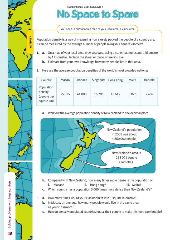
A photocopied map of your local area
A calculator
In questions 1a and 1b, the students need to locate the scale on a map of their local area so that they can then use their rulers to draw a 1 square kilometre template on that part of the map where they live. Street maps are well suited for this purpose. The scale will frequently be presented as a bar showing the relationship between map distance and the actual distance in metres on the ground. With other maps, the scale might be presented as a ratio, for example, 1 : 20 000, which reports the fact that each unit measured on the map represents 20 000 units on the ground. The students will then need to calculate how many units are required to represent 1 kilometre. For example, in the case of a 1 : 20 000 scale, they could proceed as follows: 1 centimetre on the map represents 20 000 centimetres on the ground. Therefore, 1 kilometre or 1 000 metres will equate to a length of 5 centimetres on the map. To estimate how many people live in that square kilometre, the students may find it useful to work out approximately how many people live in the portion of it that they are most familiar with. For example, a student may add up the people living in her street and then, drawing a grid system over the square kilometre, work out that her street covers about one-twentieth of the square. She would then multiply the number of people in her street by 20 to get an overall estimate. Of course, it may be that the square takes in a park, a large shopping area, or some other feature where
people are not living. Conversely, it could be that some streets have an unusually high concentration of people living there, for example, in multi-storey flats. These are factors that the students will need to consider and allow for in their calculations.
Question 2 provides data about population densities in some other places. The students may need to consult a map to see where these other places are, which may in turn provide them with clues as to why they have such dense populations. The smallness of the areas and, in several cases, their being islands are features they may notice.
Many countries, New Zealand being one of them, have large open spaces (mountainous areas, lakes, forests, farmland, and so forth) where few people live, and even our New Zealand cities have relatively low densities by international standards. It is not surprising, then, that when New Zealand’s population is divided by the area of the country (3 860 000 ÷ 268 021), the result is just 14.4 people per square kilometre. By dividing the density of the other places listed by 14.4, their population densities can be compared with that of New Zealand. In question 2b, the students are asked to do this for Macao, Hong Kong, and Malta. Question 2c
can be approached by multiplying New Zealand’s population density, roughly 15 people per square kilometre, by 3 000. This gives 45 000, which is very close to the figure of 44 000 given for Monaco.
In question 3, the students need to measure their classroom’s width and length to determine its area (in square metres) and then calculate what proportion of a square kilometre this is. They will need to realise that a square kilometre is an area of 1 000 metres by 1 000 metres, which is 1 000 000 square metres (written 1 000 000 m2. If they divide their classroom area into 1 000 000, they will find how many times their
classroom would fit into a square kilometre. By way of illustration, let’s say the classroom was 7 metres by 10 metres. This gives an area of 70 m2. Divide this into 1 000 000 and you get 14 286 (rounded to whole numbers). So, 14 286 classrooms this size would fit into 1 square kilometre. In Macao, 55 815 people live in each square kilometre, which is the same area as 14 286 classrooms (measuring 70 m2). This means that approximately four people would live permanently in this classroom space (55 815 ÷ 14 286 = 3.9). Imagining that a classroom this size represents a whole house with a kitchen, bathroom, laundry, living room, and bedrooms may help students to gain a perspective on this. In reality, many more Macao people than this
would live in this space because it must be remembered that roads, shops, parks, and so on are included in the land area to which the population density applies. Of course, the main way densely populated places overcome this problem of having so many people in such a small area is to house them in high-rise buildings.
To take a simple example, if four people occupy an area the size of the classroom mentioned above, adding an extra floor would mean that two people would occupy this same area on each of the two floors.
Answers to Activity
1. a. Practical activity
b. Estimates will vary.
2. a. New Zealand’s population density is 14.4 people per square kilometre.
b. i. 3 876 times
ii. 1 156 times
iii. 214 times (213.6 to 1 d.p.)
c. Monaco
3. a. Answers will vary. 20 000 classrooms with an area of 50 m2 would fit into a square kilometre.
b. Answers will vary. In Macao, 3 people would live in the space of a 50 m2 classroom, and 4 people would live in the space of a 70 m2 classroom.
c. In densely populated countries, many people live in high-rise buildings.