This is a level 4 geometry activity from the Figure It Out theme series.
A PDF of the student activity is included.
Click on the image to enlarge it. Click again to close. Download PDF (344 KB)
mark a pathway using scale maps and compass bearings
Copymaster of Terra Pacific chart
FIO, Levels 4-4+, Theme: Disasters Strike!, A Near Miss, pages 6-7
Other mathematical ideas and processes
Students will also:
• take into account three measures: distance, direction, and altitude
• make decisions based upon a simultaneous assessment of these measures.
Activity
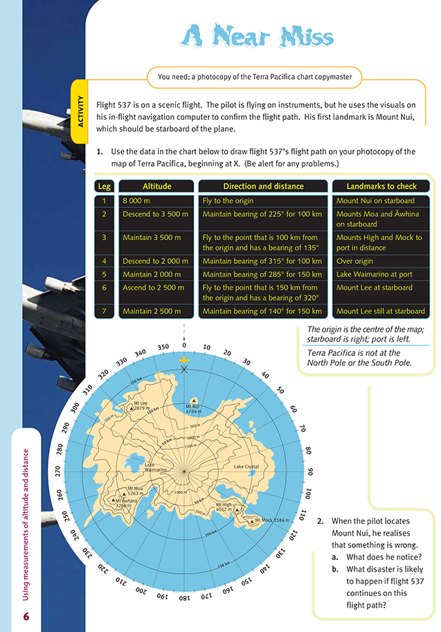
This activity will challenge even the more able students. It focuses on map reading and route finding, but it poses at least four difficulties you need to bear in mind when setting your students to work on it:
• Students may find themselves irresistibly drawn to the conclusion that they are looking at Antarctica and that the point in the centre of the diagram, the origin, is the South Pole. This confusion comes from the shape of the territory, the “pole” in the centre, the circular scale around the edge, and the explicit mention of Mount Erebus in the investigation. The problem with this is that compass bearings lose their meaning
at the poles: at the South Pole, every direction is north.
• Some of the flight directions are given as polar co-ordinates (the direction you fly and the distance you travel), while others are given as destination points (you fly directly towards a point whose location you are given). These are two quite different systems and may confuse some students.
• If students are paying close attention to the landmarks listed in the chart, they will not be able to reconcile them with the other instructions. In the first leg, Mount Nui should be on starboard (on your right as you travel), but it is on port (left). The students are asked to identify this problem in question 2.
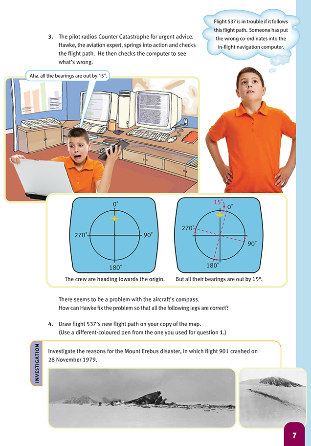
• It can be very difficult for students to interpret and fix the error of 15 degrees if they are confused about the clockwise and anticlockwise movements involved.
Looking at the four issues in order:
If this were Antarctica, the gradations around the edge of the diagram would be lines of longitude, not bearings in the sense of clockwise direction from north. If they were lines of longitude, the scale would be labelled 0° to 180° and then back to 0° because longitude is measured west and east from the Greenwich meridian.
For this reason, the diagram should be taken to represent some totally different, completely fictional country.
The students can then think of the gradations on the scale as points on a compass: 0° is north, 90° is east, 180° is south, and 270° is west. The circles are then unrelated to circles of latitude and are simply circles drawn around a fixed reference point for the convenience of the pilot (in this case, the student).
The second issue should not be a major problem as long as the students are aware that there are two different systems here for specifying the legs of the journey. In the first system, the pilot is told how far to go and in what direction. In the second system, the pilot does not need to be told the distance; only the destination.
Both are legitimate, though normally they would not be mixed like this.
Many students will ignore the landmarks when initially plotting the flight path, thinking they are extraneous details or only there for those who can’t do without them. However, when the students get to question 2, they will need to look closely at the first leg and match all the landmarks to their flight path. They should then notice
that Mount Nui is on port, not starboard, and that the flight path leads directly to Mount Lee (and disaster).
The best way for the students to feel confident about the clock direction is to hold a pencil on the chart to represent the first leg of the journey (which should have Mount Nui on starboard) and to keep it fixed there while they rotate the chart into the position they were given (Mount Nui on port). This will confirm that the
bearings have been rotated clockwise. To find the correct instructions, every compass direction on the list therefore needs to be rotated anticlockwise: just add 15 degrees to it.
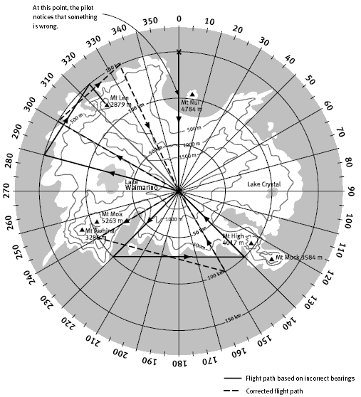
Finally, the students need to pay attention to the contours of the land if they are to see what the danger is. The tsunami activity on pages 8–10 explores the meaning of contour lines in some detail.
For an excellent summary report of the Mt Erebus disaster, visit the website
www.library.christchurch.org.nz/Childrens/NZDisasters/Erebus.asp
Cross-curricular links
Using a variety of resources, you could introduce Robert Scott’s ill-fated trip to reach the South Pole. The students could imagine that they are a member of Robert Scott’s party on this trek and write or record a set of questions that investigate what motivates an individual to explore in remote, extreme climates. They could
ask a classmate to answer the questions from their findings.
Achievement Objectives
Social Studies
Demonstrate knowledge and understandings of:
• causes and effects of events that have shaped the lives of a group of people (Time, Continuity, and Change, level 4)
• how and why people experience events in different ways (Time, Continuity, and Change, level 4)
Health and Physical Education
• identify the effects of changing situations, roles, and responsibilities on relationships and describe appropriate responses (Relationships with Other People, level 4)
Answers to Activity
1. The flight path is drawn on the map below (see question 4).
2. a. He notices that Mount Nui is on port, not starboard.
b. They would fly into Mt Lee.
3. The problem will be fixed if Hawke tells the pilot to continue to the origin and then correct the co-ordinate system on the computer by adding 15° to each of the bearings given in the flight instructions.
4. A possible flight path is drawn on the map below.
Investigation
A change of co-ordinates was given as a reason for the Erebus disaster.