This is a level 3 measurement strand activity from the Figure It Out series.
A PDF of the student activity is included.

Click on the image to enlarge it. Click again to close. Download PDF (1081 KB)
read temperatures
categorise temperatures
FIO, Level 3, Measurement, Hot Spots!, page 19
classmate
Activity One
This activity provides an opportunity to read temperatures in degrees Celsius. Students will also order one-place decimal numerals.
Questions 2 and 3 may be used as an introduction to the activity to ensure that the students can read everyday temperature data and use the term “Celsius” as the unit of temperature.
You may prefer to begin by having students collect yesterday’s temperature data from television, radio, the Internet, or from the daily newspaper. Use this to highlight the range of temperatures across the different regions of the country. Questions 2 and 3 could then be used to introduce the map. This may lead to other questions of interpretation based on logical reasoning. Help students explore questions such as: “At what time of the year do you think there are temperatures like the ones shown on the map?” “Why do you think some parts of the South Island are much warmer than
other parts?”
This leads well to Question 4. Include the proximity of the towns to the ocean, with its currents and sea breezes, as well as features such as latitude, altitude, and the position of mountain ranges to protect or channel the prevailing breezes. The cold southerly wind and the hot north-westerly wind that are common in parts of the South Island may need to be mentioned when interpreting the map.
Students may like to construct their own map showing their estimates of the average temperatures for the same places in New Zealand for each of the four seasons. They can check their estimates in the New Zealand Official Yearbook, the Metservice website (www.metservice.co.nz/knowledge), or a good New Zealand atlas.
You could also compare the more constant temperatures on small islands to the greater extremes in temperatures experienced in continental climates to show the effect of being close to the ocean. Areas such as Auckland, surrounded so closely by the Tasman Sea and the South Pacific Ocean, often have a microclimate like that of an island, while Central Otago, surrounded by mountains, has a climate similar to a continental climate.
Activity Two
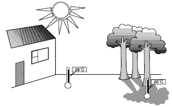
In this activity, students could also explore the concept of microclimate and the importance of the site that the students have chosen to measure. If students choose different places, this effect will be obvious. Discuss the possible difference of positions, such as sunny or shady places, as well as sheltered or exposed places. Students will need to measure the temperature at the same time each day, regardless of the weather.
Answers to Activity
Activity One
1. According to the colouring in the map:
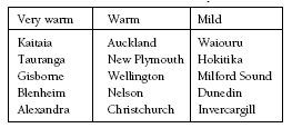
2. Very warm places: those listed in the “Very warm” column above.
3. Warm and mild places: those listed in the “Warm” and “Mild” columns
4. Answers will vary. The factors that should be discussed are distance from mountain ranges, on what side of a mountain range a town is, the prevailing wind directions, height above sea level, and latitude.
Activity Two
Answers will vary according to location.