This is a level 4 geometry and number activity from the Figure It Out theme series.
A PDF of the student activity is available.
Click on the image to enlarge it. Click again to close. Download PDF (445 KB)
interpret the scale of a map to calculate distances
calculate travel costs using a range of mental strategies
String, flexible card or dividers
FIO, Levels 3-4, Theme: Moving House, Hangin' Out, pages 6-7
A classmate
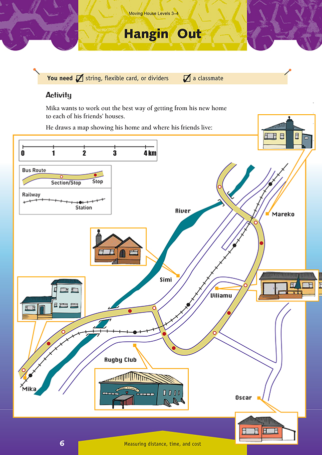
Before beginning this activity, check that the students understand the concept of scale: that is, using something small to represent something big. Maps, house plans, drawings of engines, stage sets, and model aeroplane kits – all use a scale. To be of any use, the scale must be clearly defined. In this case, it is 2 centimetres to 1 kilometre (commonly expressed as 1 : 50 000).
Ask the students how they are going to work out the distances between the various homes, bus stops, and stations. They need to do this to complete the chart and make decisions. They could use:
• a piece of string, which will follow the curves and can then be measured using a ruler
• a narrow strip of flexible card with the scale marked on the edge; this can be bent to conform to the curves of the roads or the railway line
• a pair of dividers, or a small compass, set to 1 centimetre (0.5 kilometres).
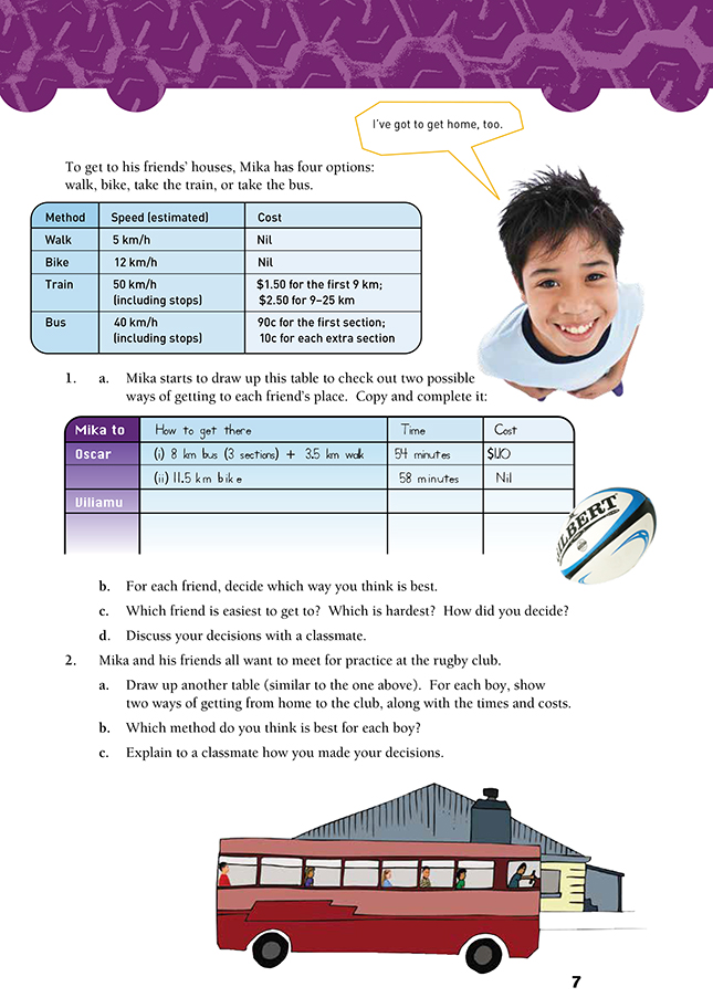
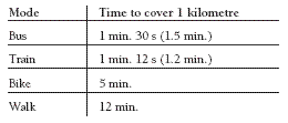
To complete the table in question 1, the students need to be able to work out time, given a certain speed and distance. Discuss with the class how to do this. A good strategy is to first work out the time it takes to travel 1 kilometre by each of the four modes. For example, the students should be able to see that if it takes 60 minutes (1 hour) to walk 5 kilometres, it will take 12 minutes (60 ÷ 5 = 12) to walk 1 kilometre, so walking times become multiples of 12 minutes. Ask them to work out the
time it takes to travel 1 kilometre by the other modes, as in the following table:
There is no right answer to questions 1b or 2b; different people will make different decisions about the best way to travel. Even in a building, one person will take the stairs, while another uses the lift.
Exercise, convenience, and speed are all factors that may influence such choices. Discuss with the students the advantages and disadvantages of using each mode of travel: fitness, convenience, cost, time taken, bus or train schedules, and time of day. For example, is it OK to bike home from rugby when it is dark in winter? What is important is that the students consider all modes of travel and can justify their decisions.
As an extension activity, the students could work out the cost of visiting a friend or relative in a different part of New Zealand or overseas. They would need to find out the costs and schedules of the different modes of transport and then make decisions as to the “best” way to travel.
Links
This activity could form part of a unit on Our Local Environment or A Great Place to Live! Ask your students to investigate why the families of people they know have moved to New Zealand from overseas. They should collate the responses, noting places of origin, reasons for the change, three positive differences about living in New Zealand, and three challenges that the families have faced in their new country. If members of the class can gather sufficient data, the students could try and make generalised statements about immigrant experiences.
Suggested achievement objectives are:
Social Studies
• how different groups view and use places and the environment (Place and Environment, level 3)
• how and why people express a sense of belonging to particular places and environments (Place and Environment, level 3).
Answers to Activity
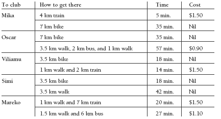
a. Possible answers are:
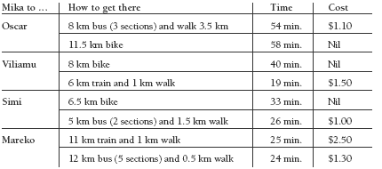
b. Answers will vary depending on reasoning. Possible answers are:
Oscar: bus and walk (11.5 km is a long way to bike)
Viliamu: train and walk (quick and convenient)
Simi: bike (not too far, cheaper, no waiting for transport)
Mareko: bus and walk (cheaper, less walking)
c. Answers will vary depending on reasoning:
Simi and Viliamu are probably easiest to get to. The hardest person to visit is Oscar: when visiting him there is no way of avoiding a fair bit of biking or walking.
d. Individual discussion. Teacher to check
2. a. Possible answers are:
b. Answers will vary depending on reasoning. Possible answers are:
Mika: train (very short, convenient stations)
Oscar: bike (faster and cheaper)
Viliamu: bike (cheaper and only takes slightly longer)
Simi: bike (faster)
Mareko: walk and train (faster, less walking)
c. Individual discussion. Teacher to check