This is a level 4 activity from the Figure It Out series.
A PDF of the student activity is included.
Click on the image to enlarge it. Click again to close. Download PDF (624 KB)
Geometry is the study of shape, size, relative position, and space and is one of the oldest mathematical sciences. The literal meaning of geometry is to “measure the Earth”. The accuracy with which we measure depends on both our needs and the sophistication of the measuring tools available. The use of satellite technology has enabled us to pinpoint places on Earth with incredible speed and accuracy. In these activities, students explore trilateration, the process of fi nding a location using distance from known locations. They also explore different representations of co-ordinates.
a classmate
6 multilink cubes
a ball of string
Mina's map (see copymaster)
a compass
FIO, Technology Transformations, Levels 3+-4+, Going Global, pages 18 - 19
Global Positioning Systems and Trilateration
The Global Positioning System (GPS) is a space-based navigation satellite system that provides reliable location and time information anywhere on Earth as long as there is an unobstructed line of sight to GPS satellites. This satellite network involves 27 Earth-orbiting satellites (24 in operation and 3 extras in case any fail), which circle the globe at a speed of 3.9 km per second at a height of approximately 19 300 km, making two complete rotations a day. The orbits are arranged so that, at any time, at least four satellites are “visible” in the sky.
The GPS was developed by the US Department of Defence to overcome the limitations of previous navigation systems. This system was later opened up for civilian use. The US government pays for the service.
A GPS receiver uses a mathematical principle called trilateration to work out its location. Trilateration is a method for determining the intersections of 3 sphere surfaces, given the centres and radii of the 3 spheres. Each satellite acts as the centre of its own sphere, and the distance to the GPS is the radius. A GPS receiver needs to know the location of at least 3 satellites and the distance between itself and each of the satellites. The satellites send low-power radio signals. The receiver can calculate how far the signal has travelled by the time it takes to arrive.
www.electronics.howstuffworks.com/gadgets/travel/gps.htm provides information on how GPS receivers work, 2D trilateration, 3D trilateration, and GPS calculations.
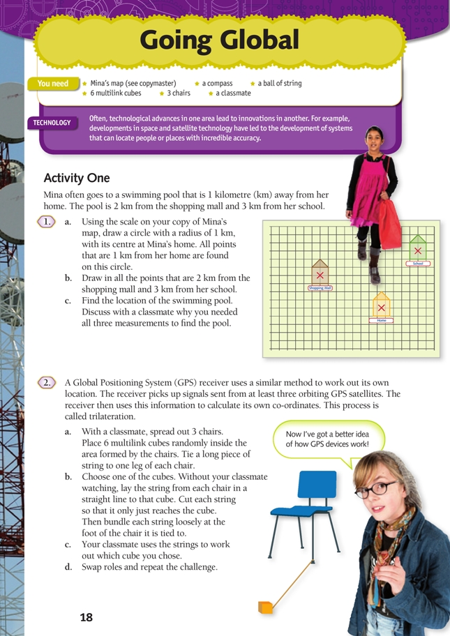
Activity One
This activity introduces the concept of loci. A locus is the set of points that satisfi es one or more specifi ed conditions. These points are often represented by a line. For example, the diagram below shows the set of points that are 4 m from the stake that the cow is attached to.
The circles that the students draw on their maps are the loci (sets of points) at certain distances from three points. If the swimming pool is 1 km from Mina’s home, 2 km from the shopping mall, and 3 km from Mina’s school, then there is only one possible location for the swimming pool.
Using a similar method, a GPS receiver can calculate its own location using its distance from 3 or more satellites.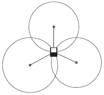
Activity Two
You may like to have two students demonstrate the cube-locating activity to the class. Reinforce the link between this activity and the previous one. The pieces of string can be used to fi nd all points a specifi ed distance away from each chair leg. In this way, the string is the radius of a circle. The intersection of the three imaginary circles gives the correct location.
Activity Three
Additional information on geocaching is available at www.geocaching.com
The following website can be used for entering the geocache co-ordinates http://itouchmap.com/latlong.html. Explore the website yourself before using it with the class to make sure that you know how to enter the co-ordinates.
Extension
Explore loci with the class. In this activity, the students move around to form different loci. This is best done outside or in a large space.
Ask students to show the locus of points:
a. 2 metres away from a particular wall
b. 2 metres away from a fi xed point (a particular object placed on the floor)
c. 1 metre away from a line segment (a piece of rope placed on the ground)
d. at an equal distance from two lines (2 pieces of rope forming an angle)
e. an equal distance from two points.
Answers (the thinner line represents the position of the students):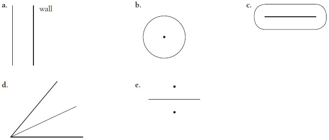
Working in groups with everyone contributing develops the key competency participating and contributing.
Students can draw sketches of loci in their books, creating stories to match each diagram.
For example, a goat is tied to a 5-metre chain, which is attached to a peg in the fi eld. Sketch the locus of all points (the area of grass) that the goat can reach.
Technology-related student activities
- Research the history of GPS.
- Search for or hide a geocache.
Exploring the technology-related context
Navigation involves knowing one’s current position and planning a route that will end up at a desired destination. Early explorers used features in the environment to guide their vessels across large distances. Other explorers used maps (which were often inaccurate) and compasses.
Developments in GPS technology allow people to navigate a path to unknown destinations with accuracy and speed.
Answers
Activity One
1. a. 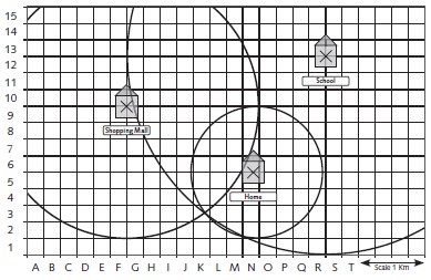
b. If 2 “known distances” are used, there are 2 possible points where the swimming pool could be located because the circles meet in 2 places. If a third known distance is added, the 3 circles only have one common point of intersection.
c. Using the grid references in the example, the swimming pool is located in square K3.
2. a.–d. Practical activity
Activity Two
1. a.
| Degrees | Minutes | Seconds | |
| Latitude | – 3 | 3 | 54.99 |
| Longitude | 37 | 21 | 32.67 |
b.
| Degrees | Minutes | Seconds | |
| Latitude | 29 | 58 | 30.54 |
| Longitude | – 31 | 8 | 15.6 |
2. The conversion gives:
| Degrees | Minutes | Seconds | |
| Latitude | – 41 | 17 | 6.4428 |
| Longitude | 174 | 46 | 2.6652 |
The geocache is hidden at the Cable Car Museum in Wellington.