This is a level 4 geometry strand activity from the Figure It Out series.
A PDF of the student activity is included.
Click on the image to enlarge it. Click again to close. Download PDF (270 KB)
give directions using grid references
square grid paper
FIO, Level 4, Geometry, Book One, Blasting Bugs, page 24
classmate
No matter where a person stands (except at the poles), every other point on the face of the earth is either north or south of them or west or east of them. In other words, from their perspective, the world can be divided into 4 regions defined by direction: NE, NW, SE, and SW. These are known as the 4 quadrants of the compass.
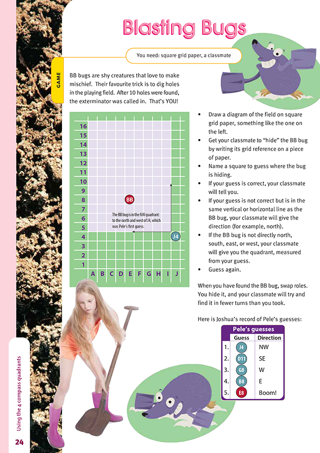
The same concept is used in this activity. If a student guesses that the BB bug is in square D3 when it is really hiding in square G1, their classmate would tell them that the bug is in the quadrant SE of D3 (the area that is to the south and the east of D3).
Note that if a student's guess is in the correct north-south or east-west line, their classmate will respond
by naming the correct direction (N, S, E, or W), not by naming a quadrant.
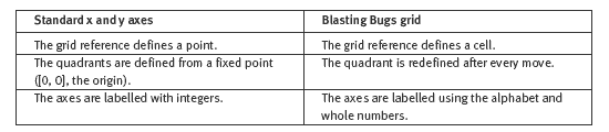
It is probably best not to try and link this grid too closely with the system of x and y axes that are the standard for algebraic functions. The two systems have these important differences that are likely to confuse students:
You could also discuss these ideas with your students:
- Although there is a northern hemisphere and a southern hemisphere, there is no true western or eastern hemisphere (these terms are, however, sometimes used). Why is this? What do we mean when we talk about "the West" and "the East"?
- Although NE (for example) is used in this activity to define a quadrant, it is also used as a precise compass direction. What does this mean, and what are the other directions marked on a traditional compass (for example, SSW)?
- What is the significance and history of the line of longitude that passes through Greenwich?
Answers to Activity
A game that involves using compass directions