Time zones
This unit introduces and explores 24-hour time and time zones.
- Read and use a variety of timetables and charts.
- Perform calculations with time, including 24-hour clock times and conversions between time zones.
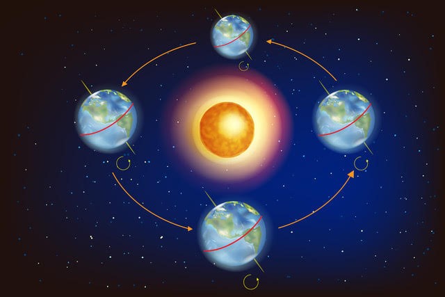
In this unit students learn that clock time varies around the world. For example, the same moment in time is read as 7:35pm in New Zealand, 5:35pm in Melbourne, Australia, and 6:35am in England, since in summer NZ is on daylight saving time. In fact, what to call a moment in time is arbitrary so nations adopt calibrations (setting of clock times) to suit the lifestyles of citizens. The Earth rotates 360⁰ every 24 hours (roughly) meaning that while it is daylight on one side of the Earth, it is night on the other side, excluding locations close to the North and South poles.
It is generally accepted that 12 noon is midday, halfway between dawn and dusk, the rising and setting of the sun. Therefore, midday occurs at different time points around the globe, based on the longitude of the location. The clocks of time zones are calibrated so that 12 noon is at the midpoint of dawn and dusk in that country. Large countries have multiple time zones, that is points at which the clock reads midday, e.g. Australia has three time zones, Russia has 11 time zones.
With the advance of communication technology and air travel, students’ lives are likely to be affected by time zones. Suppose you book a flight from Auckland to Perth. It leaves at 11:10am and arrives at 1:35pm on the same day. That seems like a flight time of only 2 hours and 25 minutes. It is hardly worth buying the entertainment and meal package. It turns out that the flight takes 7 hours and 25 minutes. That is because Auckland time is five hours ahead of Perth time. When you leave Auckland at 11:10am, the time in Perth is 6:10am.
Communicating by email, video call or phone with someone in another part of the world requires you to know the time zones. England is 13 hours behind New Zealand time. If you video call a friend at 7:00pm New Zealand time you will wake them up at 6:00am England time.
The International Date line is another complication. The line lies longitudinally between New Zealand and Samoa. It is the line created to separate one calendar day from the next. When it is Wednesday in New Zealand it is Tuesday in Samoa. It is possible to fly three hours from Auckland to Apia and arrive 20 hours before you left.
The learning opportunities in this unit can be differentiated by providing or removing support to students and by varying the task requirements. Ways to support students differentiate include:
- modelling the use of recording methods to ease the demands on working memory, such as number lines for time calculation and recording times in digital form
- acting out scenarios, using different students behaving as people at departure and arrival destinations for flights or train journeys, and using a globe and lamp to demonstrate why time zones exist
- using technology, particularly time and date calculators, to make calculations easier
- encouraging sharing and discussion of students’ thinking
- using collaborative grouping so students can support each other and experience both tuakana and teina roles
- using digital tools to explore the effect of the International Date Line and different time zones
- encouraging mahi tahi (collaboration) among students.
Differentiation is about altering activities to meet the interests of your students to enhance engagement. Since most activities are focused around international and domestic travel it is easy to choose contexts relevant to your students. For example, students might be engaged by the idea of planning a holiday to Samoa, India, or Korea, Los Angeles or the United Kingdom. It is important that you use this unit to further students’ world view as well, and explore locations they may be less familiar with. This learning can also be linked to the science contexts of learning about latitude and longitude, and the solar system.
Early navigators who travelled to New Zealand used the stars to navigate across the Pacific Ocean. Later, Lieutenant James Cook sailed to New Zealand and used the stars to calculate latitude and longitude. As a result, he was able to map New Zealand. You might choose to frame the learning in these sessions around the context of understanding how early Maori people used traditional knowledge to navigate, keep time and create maps. You could also investigate early methods used to travel between New Zealand and different islands.
- Copymaster 1
- Copymaster 2
- Copymaster 3
- Copymaster 4
- PowerPoint 1
- PowerPoint 2
- PowerPoint 3
- PowerPoint 4
- Globe
- Torch
- Atlases
- Internet access
- Connected 2, 2004, Time Zones
Session 1
In the first session we introduce the idea of time zones using a globe and by making a phone or internet call. If possible, before teaching Session 1 find an international audience to connect with (e.g. a classroom of students or whānau living in Australia. If possible, arrange to call them during this session.
- If possible, darken the room. Have someone hold the globe and another student shine the torch on it. An old overhead projector is ideal in place of the torch. You could also find a video showing the movement of the Earth and sun to show.
Imagine that the globe is the Earth and the torch is the sun. How do the sun and Earth move in relation to one another?
Students should suggest that the Earth orbits the sun.
How long does that take? (a year or 365¼ days)
Ensure that students know that the Earth rotates on its axis.
How long does a full turn take? (24 hours or one day) - Act out one day. That means little movement of the Earth around the Sun while a full rotation about the axis occurs. Note that the Earth rotates in an anti-clockwise direction (West to East) which explains why the sun appears in the Eastern sky at dawn.
Discuss what you can see with a classmate. What does this mean for people and animals living on the Earth?
Out of the discussion students should express the idea that when we are in daylight there are some places in the dark. All places, except the polar regions in summer and winter, undergo day and night in a 24-hour period. You may need to fix a blob of Blu Tack on the globe at the location of your school, and another blob at a location in another country. - Rotate the globe, stopping at various points, in the turn.
What time is it in each place?
Stop the rotation in a position when the sun is shining directly at New Zealand.
What time will this be in Aotearoa? (12 noon unless it is Daylight Savings, the time will be 1:00pm)
Think about the time in these locations:
Sydney (two hours earlier)
Samoa (one hour ahead which becomes 23 hours behind due to the International Date Line)
Shanghai (5 hours behind)
London (12 hours behind)
New York (6 hours ahead which becomes 18 hours behind due to the International Date Line)
Ask the students if they have whānau living overseas, or if they or someone from their whānau have visited other countries. Think about the time in those locations. What is the time difference between those places and Aotearoa? - There are many online videos depicting the movement of the Earth around the Sun. Be sure they represent the axis of the Earth at an angle to the plane of rotation as that explains the seasons.
- Explain that a system was invented to deal with differences. Show Slide One of PowerPoint 1 that shows time zones.
Talk to a classmate about what you notice on this map of the world. Be ready to explain what you see to everyone else. - In the following discussion try to bring out the following points:
- In Coordinated Universal Time, Zone Zero is called Greenwich Mean Time (GMT) and is the time zone of countries like Spain, England, Algeria and Mali. Note that these countries are within the same longitudinal vertical strip. Iceland is also in that zone. Since 1968, Iceland has observed GMT all year round. Prior to this, different cities in Iceland observed time zones. Iceland does not have any international borders. Therefore, there was no idea for a time set in relation to neighbouring countries. Daylight Savings was introduced between 1917 and 1921 to allow for more efficient communication (it was around this time that the telephone was introduced to Iceland). Ultimately, GMT was chosen because the moving forward of clocks for Daylight Saving was seen to cause hassle and stress for the Icelandic people. Moving to GMT also meant Iceland was “in sync” with the rest of Europe. Like Iceland, New Zealand had also adopted a local time system. This meant that life was organised, in each city and town, in accordance with its own time zone. By 1868, the use of telegraphs and the post office was becoming more popular. However, having different time zones in different localities meant that different post offices opened and closed at different times. This made it difficult to send and receive any urgent messages. In 1868, and after a lot of arguing between localities, it was decided that New Zealand’s clock time would be 11 hours 30 minutes ahead of GMT. Eventually, in 1946, New Zealand adopted a standard time set 12 hours ahead of GMT, or 180° east of Greenwich. Your students might be engaged by the idea of investigating the time zones of different localities prior to 1868.
- New Zealand lies in Zone 12 and Eastern Australia in Zone 10.
- To work out the difference in time between two countries, count how many zones they are apart. For example, New Zealand and Peru are seven zones apart so the time in Lima is 7 hours ahead or 17 hours behind that in Wellington.
- Ask: Have you ever tried phoning or Skyping someone in Australia? It’s [time] at our place. They live in [location]. What will the time be over there?
- Let students predict the time in the Australian location using the time zone map.
- Contact your pre-arranged person/group of people living in Australia. This could be done with Zoom, Skype, Google meets, a cell phone etc. Consider using a video calling application to make the activity more engaging for your students. Be sure to ask them the current time in their location.
- Discuss: How many time zones do you think Australia has? (three)
Let students use the map.
Why does Australia have three time zones? (It is a big country from West to East). - Look for Russia on the map.
How many time zones does Russia have? (11 zones) - Provide the students with copies of Copymaster 1 to work from in pairs. After a suitable time, discuss the answers together as a class.
- Question One: This is an open-ended problem so many different answers are possible. From New Zealand any city in South-East Asia will work, such as Kuala Lumpur, Saigon, Bangkok will be five hours different. Mountain State cities in USA such as Denver and Salt Lake City are 5 hours different as well. Any city can be chosen as the reference.
- Question Two: Mumbai is 7 hours behind New Zealand time. To ring her friend at 8:00am Lucy needs to ring at 3:00pm NZ time. To ring her friend at 6:00pm she would need to ring at 1:00 am NZ time.
- Question Three: Ireland is 12 hours behind NZ time. The rugby test will start at 7:35am NZ time.
- Question Four: Korea is four hours behind New Zealand time. The plane takes off at 5:15 am Korean time and lands at 6:15 pm (13 hours later).
- Question Five: The flight time from Buenos Aires to Auckland is 13 hours and 30 minutes. Buenos Aires is 16 hours behind New Zealand time. Suppose Waimarama leaves Buenos Aires at 10:00pm of 1 January. Her birthday is on 2 January. The time of departure is 2:00pm New Zealand time on the following day, January 2. By the time she flies for 13.5 hours the time she lands is 3:30am on January 3. She misses all of 2 January.
- Question Six: New Zealand has a special time zone for the Chatham Islands so it has two time zones.
Session 2
In this session students learn to express am and pm times in 24-hour time. They use 24-hour time to make calculations about time difference between two different locations.
- Use PowerPoint 2 to introduce the lesson. Work through the first five slides setting the context of departing on an International flight. Slide Five has a paper boarding pass and asks students to find important information. The time on the pass is 18-45 which might be written more correctly as 18:45 or 1845.
What does a time of 18:45 mean?
Some students may know that the time is given in 24-hour time, sometimes referred to as military time.
Why is 6:45pm expressed as 18:45? (It is 18 hours and 45 minutes from the start of the day at Midnight.) - You may need to demonstrate counting in hours and minutes until 18:45 is reached, noting the significance of 12:00 noon as the halfway point through a 24-hour day. Proceed through the slides showing other boarding passes to work out the 24-hour times.
- Copymaster 2 provides a sequence of problems for students to practise reading and writing 24-hour time. Students could work on the problems independently at first, although some may be best supported by encouraging mahi tahi (collaboration) among students. They should share and discuss their thinking and answers.
Session 3
In this session the class practise working with 24-hour time in the context of the commuter train that runs from Waikanae to Wellington. Use of 24-hour time for public transport is quite rare in New Zealand but is common in Asia and Europe.
- Look at the first three slides of PowerPoint 3 to introduce the context of two commuters, Henare and Leisha, who work in central Wellington. Commuting can result in long working days.
What does it mean to commute to work?
Why might people use public transport to commute rather than drive their car? (Cost, time, and minimising carbon footprint are important reasons)
If you were Henare and Leisha what would be the best time to start work? Explain why you would start then. - Slide Four has the early morning timetable for the Kapiti Line. It is a simplified timetable compared to the actual timetable but the times are real.
How much time does it take Henare and Leisha to train from Waikanae to Wellington? (Note that there are two services; normal and express)
How much longer does it take the normal train than the express train? (3 minutes)
Which trains are likely to be the most packed? Why? (Trains arriving in Wellington between 7:45am and 9:00am are likely to be popular)
Which train would you advise Henare and Lisa to take? Why? - Encourage the students to consider the ramifications of beginning early or late to avoid the peak periods. An early start means an early return to home, especially if two hours of work can be completed on the train, using the internet.
- Once the students select a start time show Slide Five which shows the afternoon/evening timetable for Wellington City to Waikanae. Choose several times to see if students recall how to convert from 24-hour time to pm time. For example, the 17:01 train departs at 5:01pm.
- Provide the students with Copymaster 3 to work from in pairs. Consider pairing up more knowledgeable and less knowledgeable students to encourage tuakana-teina.
Look to see that your students:- read 24-times correctly and transfer those times to am and pm 12-hour times
- recognise that minute and hour times are based on 60, and calculate times appropriately
- build with the 24-hour times for existing trains to schedule the new services
- consider that several services might be rescheduled to accommodate the new trains to best advantage
- factor in the loss of ‘on train’ working time when calculating the advantage that Henare and Leisha gain from their move
- support each other, and share and discuss their thinking.
Session 4
In this session students investigate departure and arrival times of international flights. Students are given two of three conditions and asked to find the third. Departure time, flight time or arrival time might be omitted. In solving the problems students need to compare time zones using 24-hour time and make calculations with time in hours and minutes.
- PowerPoint 4 shows animations of three flights. Clocks show the times at departure and arrival locations. Ask questions like:
What is the time difference between Brisbane and Singapore?
What do you notice about the clocks at each location as the flight proceeds?
From the departure times in each location how could you calculate the flight time?
If you are told the flight time how can you calculate the arrival time in the country that you land in? - The last question is the most common problem that travellers face. Arriving in an unfamiliar location late at night is alarming and sometimes leads to dangerous situations while travelling to accommodation. The easiest method is to work out the departure time at the arrival location. For example, in summer Adelaide is 2½ hours behind Auckland. An Auckland flight that departs at 2:59pm (1429) is leaving at 12:29pm (1229) Adelaide time. If the flight lands at 5:18pm (1718) then the flight time is calculated as 1718 – 1229. 17 – 12 = 5 hours but the flight is slightly less than that. 18 – 29 = -11 minutes so the flight is 5 hours less 11 minutes or 4 hours and 49 minutes.
- Model the flight time calculation for each of the three flights shown on PowerPoint 4. Slide Seven has the departure and arrival times of an Auckland to Perth flight. Students might be tempted to calculate the flight time as 2150 – 1925 = 2 hours and 25 minutes. This calculation does not include the time difference. Since Perth is 5 hours behind New Zealand time the flight leaves at 1425 (Perth time) not 1925. The flight time is 2150-1425 = 7 hours and 25 minutes.
- Give your students copies of Copymaster 4 to work from. Students will need to access a site like www.timeanddate.com/worldclock/ to find the time difference between cities and also use google maps, or a similar programme, to establish where those cities are. Look for students to convert the departure time at the origin to the time at the arrival destination, then find the difference between arrival and departure times. Do students recognise that time operates on a base of 60 so that normal decimal calculation methods need to be adjusted?
- Finding missing arrival and departure times involves a similar process. Either change the departure time into the time at the arrival location or change the arrival time into the time at the point of departure.
Session 5
In this session, the class practise using timetables and their knowledge of time zones to plan a trip to London from where they live. You could complete this task as a class, or in small groups, and then give pairs of students the opportunity to plan a trip to a destination of their choosing. This could be linked with social sciences learning.
- Pose the challenge:
You are going to have a three-week holiday in the United Kingdom (UK). I want you to plan the trip. Both your parents work, so you cannot leave before December 6th and you cannot return later than December 26th. Plan the transport that will give you the longest possible time in the UK. Allow for travel time, stop overs, and minimalising the overall cost. Use the internet to help you but please don’t book any flights by mistake? - Get the students to report back with their results. Who was able to get the longest time in the UK? Who allowed for stopovers in important nexus locations like Singapore or Dubai? Who balanced cost with efficiency? (Cheap flights often take a long time) The students might like to think of important locations to visit in the UK, such as Buckingham Palace, Stonehenge and Strawberry Fields. They could plan an itinerary for the trip.
Dear family and whānau,
This week we have been working with 24-hour (military) time, discovering how time zones work and why the zones are needed. We have calculated times in other parts of the world when given New Zealand time, and found out how to work out arrival times for long international flights.