This is a level 3 link geometry activity from the Figure It Out series. It relates to Stage 6 and 7 of the Number Framework.
Click on the image to enlarge it. Click again to close. Download PDF (765 KB)
use compass points and bearings to give instructions
In questions 1–4 of this activity, students interpret a simple diagram in order to describe distances and direction in terms of kilometres, compass directions, and degrees from north. No calculations are involved. Question 5 involves rates, and students will need to be Advanced Multiplicative thinkers (Number Framework,
stage 7) to be able to complete it.
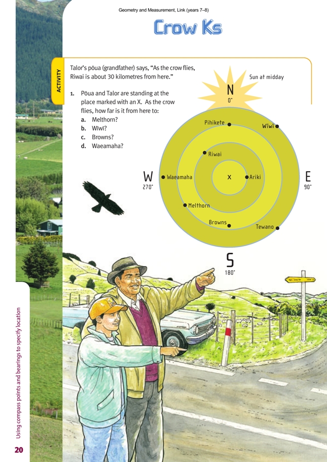
It is unlikely that students will be familiar with the kind of diagram on which this activity is based. It looks as if it is meant to be a map (given that it’s got towns and compass directions on it), but it doesn’t have all the other usual features of maps (such as roads, rivers, hills) and it does have those unusual concentric circles.
Introduce the activity with a discussion on the meaning of the phrase “as the crow flies”. The phrase refers to the shortest distance between two places: the length of the imaginary straight line joining them. Unlike us, a bird (crow) is not obliged to follow roads that wind around the natural and created obstacles like hills, rivers, lakes, and private property, which add length to a journey.
Scaffolding for question 1 could go like this: Talor’s pòua (grandfather) says Riwai is 30 km away from where they are standing (the place marked with an X).
- If this is the case, how far would the crow have flown when it crossed (any point on) the first circle? (15 km, because it is halfway between the X and Riwai)
- So what does the gap between each circle mean in terms of distance? (Each circle marks off another 15 km distance from Talor and his pòua.)
- How could you use this information to help you work out the distance to Browns? (You’d have to estimate that Browns is about of the way along the distance between the second and the third circles; of 15 km is 10 km. 15 + 15 + 10 = 40 km)
The information panel for question 2 explains how directions should be worded. Most students won’t have met the terminology “due west”, so explain that this means “directly west” and is used to make it clear that we are not talking about a direction that is just more or less westerly. Explain also that in addition to the 4 cardinal points of the compass, there are 4 intercardinal points: north-west, north-east, south-east, and south-west. Like the cardinal points, the word “due” can be used with them to make it clear that we mean precisely that direction. Question 3 hinges on the word equidistant; its meaning is explained in the information panel.
Question 4 is about giving direction as a number of degrees measured clockwise from due north. The diagram shows the degree equivalent for each of the 4 cardinal points, and students have to estimate the direction of each town. It is usual to express bearings as 3-digit numbers (for example: 005°, 059°, 184°).
Note that direction by compass points (question 2) and direction by bearings in degrees (question 4) are two different systems that get along comfortably together. Students may wonder why there are two systems. The reasons are historical. The first is older, less precise, and more clumsy. (It’s difficult to specify a direction that is not conveniently halfway between two named directions.) The second is more recent, precise, and allows for any direction to be specified with equal ease. Both systems reflect the navigational needs of their times.
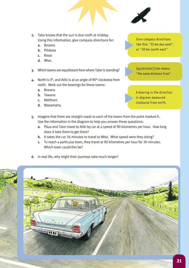
If students find question 5a difficult, encourage them to draw a double number line and ask them questions that will scaffold their thinking.
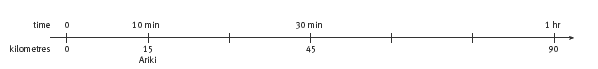
- If the pair travelled for a whole hour at 90 km/h, how far would they get? (90 km) Show this on your number line.
- How far would they have travelled in half an hour? (45 km)
- How far away is Ariki? (15 km)
- Where on the line would you put 15 km? (1/3 of the way between 0 and 45 km, or 1/6 of the way between 0 and 90 km)
- How could you use the numbers on the double number line to work out how long it would take to travel 15 km at 90 km/h? (1/3 of 30 minutes is 10 minutes, or 1/6 of 60 minutes is 10 minutes)
In question 5b, the car takes 36 minutes to travel 60 km:
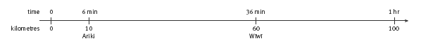
- How far would the pair have travelled in 6 minutes? Show where you’d put 6 minutes on your number line.
- Now that you know they travelled 10 km in 6 minutes, can you use that to work out how far they would have gone in 1 hour if they’d kept going at the same speed?
- What speed are you doing if you travel 100 km in 1 hour? (100 km/h)
In question 5c, the car takes 30 minutes travelling at 90 km/h to reach a particular town:
- How far would the car get if it travelled for a whole hour at this speed? (90 km)
- They only travel for half an hour, so what part of 90 km should they cover in this time?
- Which towns are 45 km from X? (Melthorn and Pihikete)
Extension
If your school has a set of orienteering compasses, show your students how to use these and then get them to find the bearings (in degrees, clockwise from north) of various points around the school, taken from a variety of vantage points. This could lead into some simple orienteering. (Going Places, page 19, could be used as a starting point.)
Answers to Activity
1. a. 45 km
b. 60 km
c. About 40 km
d. About 55 km
2. a. 40 km due south
b. 45 km due north
c. 30 km north-west
d. 60 km north-east
3. Pihikete and Melthorn, Tewano and Wìwì
4. a. 180°
b. 135°
c. 230°
d. 270°
5. a. 10 min. (90 km in an hour is the same as 30 km in 20 min or 15 km in 10 min.)
b. 100 km/h. 60 km in 36 min is the same as 10 km in 6 min or 100 km in 60 min, which is 100 km/h.
c. Melthorn or Pihikete. 90 km/h is the same as 45 km in 30 min. Both these towns are 45 km away “as the crow flies”.
6. Answers will vary. Possibilities include: the road detours to cross a river or avoid a mountain, a winding road, a steep road, 50 km/h zones, a narrow or unsealed road, a dangerous road, a lot of traffic on the road, bad weather, a breakdown, or stopping
for someone who is feeling carsick.